THE CHALLENGE
Accurate 3D mapping and depth perception are critical for the future of autonomous navigation, robotics, and aerial imaging, yet today’s industry fights a frustrating battle between hardware weight and computing power. Standard dual-camera systems require bulky, synchronized hardware that adds severe payload weight and demands constant calibration making them impractical for smaller, agile platforms like micro-drones. To save weight, some industries turn to single-camera solutions, but these rely on complex, repetitive processing loops that drain batteries and introduce dangerous lagging. Even worse, these traditional single-camera methods often lose track of scale or freeze up entirely during straightforward, forward-line movement when visual changes are minimal. As a result, commercial innovators are left without a lightweight, low-power solution that can reliably deliver fast, pinpoint 3D accuracy directly on mobile devices and edge hardware.
OUR SOLUTION
This innovative system delivers high-precision 3D mapping using just a single standard camera and basic motion data. Instead of relying on heavy dual-lens hardware or power-hungry AI, the software captures two quick snapshots from a moving device and instantly simulates a "virtual second camera" to create a perfect stereo pair. By calculating the mathematical intersection of light paths on this virtual plane, the system instantly measures depth and generates highly accurate 3D point clouds. Because it uses elegant, direct geometry rather than slow, repetitive computing loops, it provides real-time spatial awareness without draining batteries or requiring expensive processors.
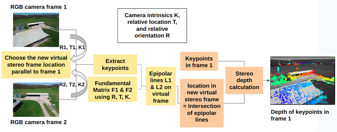
Figure: Diagram illustrating how the system uses virtual frame simulation and direct geometry to calculate depth bypassing the need for complex, iterative computing loops.
Advantages:
- Lower computational overhead and faster execution
- Reduced hardware weight and payload costs
- Eliminates the “Forward Motion” blind spot
- Avoids requirements for massive training data and AI computation
Potential Application:
- UAV aerial surveying and GIS mapping
- Navigation of autonomous vehicles and advanced driver assistance systems
- Autonomous mobile robots and warehouse automation
- Augmented reality and mobile spatial computing
- Tactical reconnaissance, defense, and search and rescue